Geological Survey Ireland is producing wonderful data resources, impossible to resist when it comes to doing some analysis. In this post, welook at bedrock data, what you would see after sweeping away all the soil and loose covering from the ground. Bedrock is stuff like sandstone, limestone, igneous rock….
I was interested to see how overlying vegetation depends on the bedrock; specifically if the colours from satellite images taken at different times of year could be used to take a guess at what lies beneath.
This requires two suites of information, the bedrock data from GSI and the satellite data from Copernicus-Sentinel. The first we’ll download directly and store locally from this resource, the second we’ll access using the R package, sen2r (but we’ll also end up downloading and storing image files locally, but sen2R will help scope them out).
This was originally written as one post, but then it got so long I decided to split it into three parts:
- Part I: getting the bedrock data from GSI
- Part II: getting the satellite data from Sentinel
- Part III: putting the first two together
ref <- st_read("data/Shapefiles/Bedrock_Polygons_ITM_2018.shp", quiet = TRUE)
my_proj <- "+proj=utm +zone=29 +datum=WGS84 +units=m +no_defs"
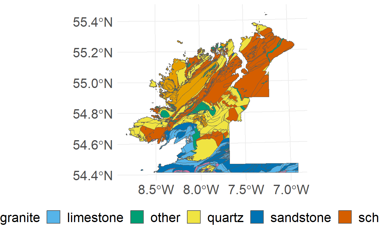
ref <- st_transform(ref, crs = my_proj)The bedrock file arrives in the form of a shapefile. It contains bunch of attributes: location, decription, area, as well as the polygon shapes themselves. And some attributes I’m at a loss to understand (M, Y, K, C anyone?). We end up with a total of 25,958 fields covering the Republic of Ireland.
Below we show the geometry for this shapefile:
Geometry set for 25958 features
Geometry type: MULTIPOLYGON
Dimension:     XY
Bounding box:  xmin: 384779.9 ymin: 5696646 xmax: 701597.5 ymax: 6145919
CRS:           +proj=utm +zone=29 +datum=WGS84 +units=m +no_defs
First 5 geometries:
And here is a table showing the attributes for a sample of a few fields. Note, we’ve done a wee text-trawl through the description attribute to try and categorise the rocks in to a manageable number of types (quartz, sandstone, limestone, schist, shale, granite, or other).
| class | NEWCODE | DESCRIPT | UNIT_NAME | M | Y | K | C | LABEL | SHAPE_AREA |
|---|---|---|---|---|---|---|---|---|---|
| limestone | CDTOBE | Calcareous shale, limestone conglomerate | Tober Colleen Formation | 20 | 20 | 0 | 40 | TC | 1,943K |
| schist | OTMAUL3 | Dark grey semi-pelitic, psammitic schist | Ballybeg Member | 15 | 30 | 0 | 10 | MNbb | 821K |
| schist | LCRQ | Psammitic schist, some marble beds | Lower Crana Quartzite Formation | 30 | 40 | 0 | 0 | LC | 41.17 |
| sandstone | DUOHSF | Flaser-bedded sandstone & minor mudstone | Old Head Sandstone Formation | 0 | 50 | 0 | 0 | OH | 1,766K |
| limestone | CDRATH | Pale-grey massive mud-grade limestone | Rathronan Formation | 10 | 0 | 0 | 20 | RR | 249K |
| quartz | MRBENQ | Pale quartzites, grits, graphitic top | Bennabeola Quartzite Formation | 0 | 70 | 0 | 0 | BX | 119.39 |
| other | SMBRDF | Fine to conglomeratic graded greywacke | Broadford Formation | 10 | 50 | 0 | 30 | BF | 11K |
| sandstone | S*GCRA | Thin-bedded sandstone & mudstone | Glencraff Formation | 10 | 30 | 0 | 10 | GC | 58K |
| other | IOMGAB | Hornblende metagabbros & metanorites | Metagabbro and Related Lithologies | 0 | 40 | 0 | 70 | Mg | 33.45 |
| sandstone | DUCARR | Red, brown conglomerate & sandstone | Carrigmaclea Formation | 40 | 70 | 0 | 30 | CI | 1,364K |
Plotting this, and just looking at the NorthWest, we get: